HOME
Cotopaxi Volcano
Cotopaxi National Park (Ecuador)
© Stéphane Guisard, Los Cielos de América
Located in Ecuador and reaching a height of 5,897 m (19,347 ft),
Cotopaxi is one of the highest active volcanoes in the world and the second highest summit in the country. Its name means "Smooth Neck of the Moon", and was honored as a "Sacred Mountain" by local Andean peoples, even prior to the beginning of Inca domination in the 15th century. It was worshiped as "rain sender", that served as the guarantor of the land's fertility and at the same time it's summit was revered as a place where gods live.
Cotopaxi has an almost symmetrical cone that rises from a highland plain of about 3,800 metres (12,500 ft), with a width at its base of about 23 kilometres (14 mi).It has one of the few equatorial glaciers in the world, which starts at the height of 5,000 metres (16,400 ft). The mountain is clearly visible on the skyline from Quito. It is part of the chain of volcanoes around the Pacific plate known as the Pacific Ring of Fire. The first European who tried to climb the mountain was Alexander von Humboldt in 1802, however, he only reached a height of about 4500 m. In 1858 Moritz Wagner investigated the mountain, but he could not reach the summit either. On November 27, 1872, geologist Wilhelm Rajss finally reached the summit of Cotopaxi.
There have been more than 50 eruptions of Cotopaxi since 1738. Numerous valleys formed by lahars (mudflows) surround the volcano. This poses a high risk to the local population, their settlements and fields. Cotopaxi's most violent eruptions in historical times occurred in the years 1744, 1768, and 1877. In the 1877 eruption pyroclastic flows descended all sides of the mountain, with lahars traveling more than 100 km into the Pacific Ocean and western Amazon basin draining the valley. There was a major eruption in 1903 through 1904, and some minor activity in 1942 as well as 1975 but it did not produce any major events. In the most recent case, fumarolic activities and sulfuric emissions increased and ice around the inside and on the southeastern side of the cone started to melt. The main danger of a huge eruption of Cotopaxi would be the flow of ice from its glacier. If there were to be a very large explosion, it would destroy most of the settlements within the valley in the suburban area of Quito (pop. more than 1,000,000).Another city which would be in great danger is Latacunga which is located in the south valley. In 1744 and 1768 an eruption destroyed the colonial town of Latacunga.
(Text above from Wikipedia.)
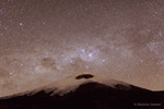
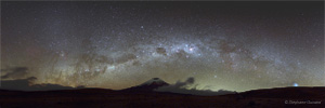
Cotopaxi volcano time lapse movies made at altitudes of 3800m and 4500m. Cotopaxi Volcano is very close to the Equator line, explaining why in this time lapse movie the celestial Southern Pole is located on the horizon behind the volcano. The coal sack and Southern Cross are visible above the crater. One can also see the flashlights of climbers going up the glaciar.
Zoomable and 'full-screenable' Cotopaxi panorama picture showing the Southern sky Milky Way arch above the volcano. Scorpius constellation is rising to the left, Coal sack and Southern cross are above the crater while Sirius, the brightest star of our sky, is setting on the horizon to the right.
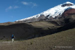
The Volcano and the photographer.
It is literally "breathtaking" to walk and climb in these beautiful landscapes at such altitude (4500m) with 21 kg of equipment (cameras, tripods, batteries). Because of this altitude, you MUST have a written check list in order NOT to forget anything, even obvious ones (because your brain might work slower due to the lower air pressure) : adjust correctly all the camera parameters, put a memory card in the camera, focus the camera, switch ON the camera also, eventually remove the lens cap... etc ... well ... in this case ... the ONLY ONE thing I forgot ... was to take the checklist along with me ...
